XE Explains: extreme temperatures and weather patterns
Extreme E: Why is Europe and much of the planet experiencing extreme weather patterns?
Professor Richard Washington: On 5 July 2023 a new global average temperature record of 17.05 oC was set. A day earlier, on the 4 July, that figure exceeded 17 o C for the first time in the earth’s instrumental weather record. Extreme heat has been experienced across a number of regions, including southern parts of the US, China and the Mediterranean. Meanwhile, wildfires are spreading across the Canary Islands and Algeria and have led to evacuations in Greece on the islands of Rhodes and Corfu. In Arizona, Phoenix experienced in excess of 43 oC for 19 days in a row – a new record of persistent extreme heat.
Not everywhere is hot at the moment, though. London is currently seven degrees cooler than the July average – a far cry from the record breaking 40.3 oC recorded in Lincolnshire this time last year.
Extreme E: What is the cause of such extremes?
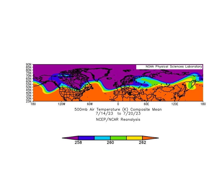
RW: The immediate cause of the regional extremes in temperature is the pattern of winds in the upper air over the northern hemisphere which can be thought of as where the jet stream is found. The jet stream (in the northern hemisphere) separates hot air to the south from cold air to the north. The gradient between the hot and the cold air is often very sharp. The map below shows that gradient in temperature for the northern hemisphere from 14 July to 20 July 2023. The yellow colour more or less marks out that separation.
The yellow line is wavy rather than straight west to east. In parts of the world, like south west USA and the Mediterranean, the wavy yellow line bulges northward, showing that hot air is found further north than usual. Those bulges are technically things called ridges of high pressure which are characterised by sinking air, cloud-free skies and hot conditions.
Air that sinks from the top of the atmosphere to the surface through a depth of 10 kilometres, will heat by 100 degrees C as a result of compression. That heating and the very dry air which originates at the top of the weather atmosphere leads to extremely low relative humidity which kills off any cloud. Sunshine, which is near the annual maximum, pours through over the course of the long daylight hours. Given all of this, it follows that conditions are extremely hot.
For somewhere like the Med, Saharan conditions prevail. The air over the Med and the air over the Sahara is pretty much inseparable. There is one further ingredient, and that is a dry surface. All the sunshine is converted into heat we can feel (sensible heat) when there is no water to evaporate. Meanwhile England is in a cool part of the wave – a trough rather than a ridge.
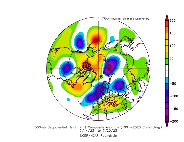
The wavy flow of the jet stream around the northern hemisphere at the moment is called a Wave 5 pattern because it has five high pressure ridges (where the yellow in the figure bulges north) and five troughs (where the yellow spreads south). The Wave 5 pattern is more easily seen in the figure below which shows the pressure anomalies (for example, what is unusual about the pressure) 5km up in the atmosphere. Wave 5 patterns tend to move slowly, usually from west to east. This helps to explain why the heat over the Med and the US has been so persistent.
Of course, Wave 5 has happened before in the northern hemisphere summer. And has caused heat waves. It is a well-known pest. Each time it occurs, the carbon-dioxide levels are higher, the heat available to the atmosphere is higher, the surface under the ridges of the wave drier and the wave a bit more stubborn. And so, records are broken.
Extreme E: Have the extremes been building for a number of years?
RW: Increasing extremes in temperature and rainfall across the planet are building as the carbon-dioxide levels increase year on year. The climate system has no other option than to get hotter. There’s an added player in 2023 which is El Nino. El Nino, the appearance of unusually warm water across the tropical central and eastern Pacific, releases heat from the ocean to the atmosphere. So much heat is released that El Nino years are globally warm years. El Nino will speak to 2023 and 2024 global temperatures.
Extreme E: How long are the current extremes in heat set to continue?
RW: The persistence of the heat wave in the Med depends on what Wave 5 does. Usually the wave moves slowly west to east and it is doing that. Initially the extremes in this episodes were in Spain, then Sardinia and Italy and now Greece. The hotter the outbreaks in each of the hot spots, the slower the wave moves and the longer the heat waves last. That’s because those enormous blobs of hot air are hard to dislodge.
Extreme E: What are the dangers in Sardinia?
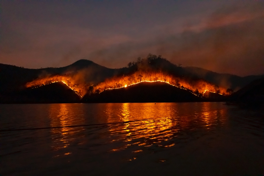
RW: The temperatures in Sardinia have been dangerous. Last summer’s temperatures caused an excess of 61,000 deaths across Europe. The heat is damaging to ecosystems both on land and sea. There are also wildfires across south east Europe, most notably in Greece. I was lucky to escape Corfu a few days ago, just a few hours before the wildfires started there.
I know this is trivial, but it is some sort of a touchstone. I was unable to charge my phone in a shaded room in an old house before leaving. An error message on the screen showed that it was simply too hot.
Extreme E: Are the wildfires set to continue?
RW: Wildfires will persist through the heat wave. The vegetation in the Med is extremely dense and extremely dry. This provides the fuel for the fires and there is plenty of it. There are related events which can cause these fires such as lightning strikes which are the product of intense storms, nature’s way desperately of trying to cool the planet.
Extreme E: Mitigation work has already taken aboard on the St. Helena. How important is that?
RW: In the run-up to the Island X Prix, the Lidar system was set up on the St Helena while she was at anchor. We measured the outbreak of Saharan air bound up with the start of the Wave 5 pattern that is key to the heat wave experienced over southern Europe. The beginnings of that heat wave were clear to see because the air was laden with dust from the core of the central Sahara, the cauldron which at this time of the year is the largest source of dust on the planet. We were able to measure that harbinger early on the start of the heat wave.
Extreme E: What other mitigation measures can be put in place?
RW: Clearly stopping carbon emissions is key to mitigating extremes. This is a massive global effort that drives Extreme E along. But it will take time. Meanwhile, on the ground, efforts to closely monitor the onset of wildfires when there is still a chance to extinguish them, is one important way forward. In this regard, the efforts of Vodafone Business to develop appropriate instrumentation to detect wildfires, serves as a fine example of what can be done. Without early warning, we have little or no way of getting to the fires before it is too late.

Extreme E: How important is it to raise awareness of the crisis?
RW: The need to wean ourselves off carbon has never been more obvious. Extremes really bring it home. In the case of wildfires, we are having to confront the outcome of increasing carbon in the atmosphere in the most frightening of ways.
